Earlier posts

Earlier posts
This blog is a continuation of an older one. To explore previous posts please click the photo above.
Showing posts with label moors. Show all posts

Thursday, 19 June 2025

Wild Uplands #3


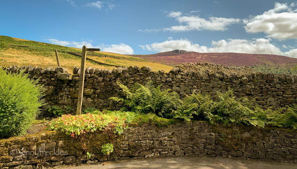
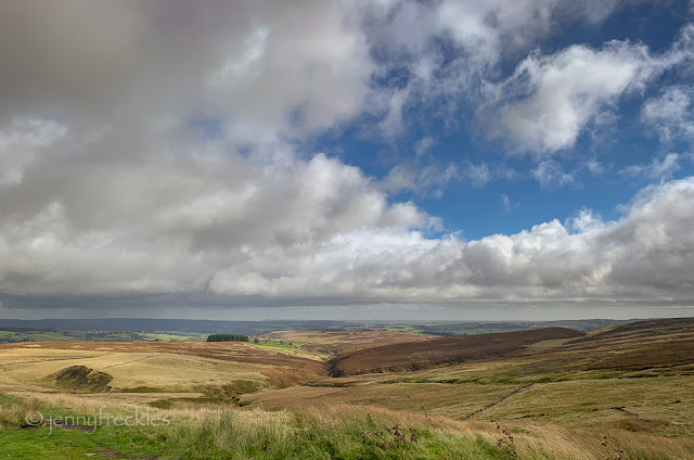
Here's my own 'take' on the 'Wild Uplands' above Haworth. Honestly, who needs artworks when you have all this beauty? There are layers and folds in the landscape, gradually assuming a purplish hue as the heather starts to bud. 


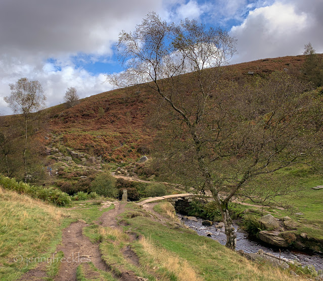
Tumbled chunks of gritstone lie in the hollows, felled by some unseen force. Ferns push their way resolutely upwards through the thin soil.

The moors that the Brontë sisters trod are gradually being tamed. The heather, once prevalent, is gradually dying back as grass, bracken and bilberries march across the land. 

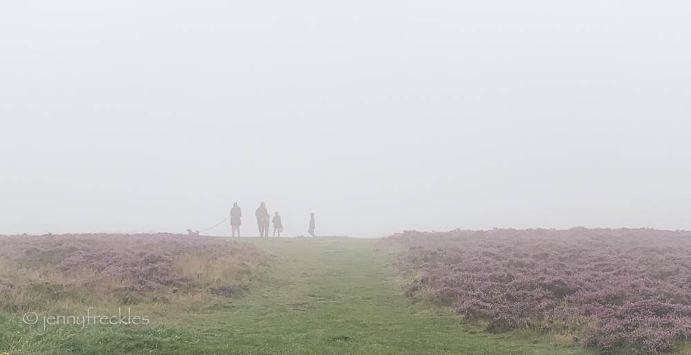
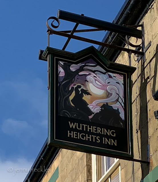
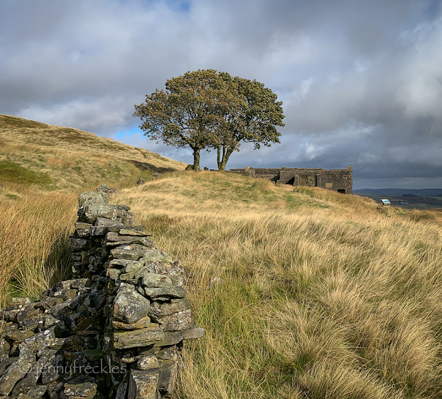
In the far distance on the mid-right in the photo below, you can perhaps just discern the ruined farmhouse and the lone tree at Top Withens, reputedly an inspiration for Emily Brontë's 'Wuthering Heights'. (See HERE for more detail.) 


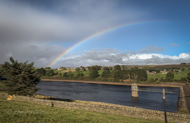
Lower Laithe Reservoir (below), like all our watercourses, is somewhat low in water due to our very dry spring weather. 


As I was exploring, I stumbled - almost literally - across another artwork, this time rather older. It consisted of various embedded stones carved to look like books. It's entitled 'Literary Landscape' by Martin Heron and was installed in 2003. There are apparently ten of these sandstone carvings scattered across the moorland, the books not titled, but prompting us to recall our own favourite 'literary landscapes'. Gradually the moor is reclaiming them so they look 'planted' in the soil.  

Monday, 10 March 2025

The moor road


It's a drive of about 16 miles to my daughter's, by the direct route. The direct route is over the high moors that divide the Calder valley from the Aire valley. It can be beautiful up there. It's also rather bleak and the weather can be very different up there from down in the valleys. It's often foggy, or conversely often windy, can be snow and ice up there even when there's none lower down. Even though I have winter tyres on my car, I would never choose that way if I thought it would be dangerous or beyond my driving capability - though the two alternatives also have quite steep hills to navigate, as well as being longer.

When I drove over the other day, the weather wasn't a problem. When I got home I noticed, however, some posts online about a 4x4 that had been driving dangerously up and down the road and deliberately ramming other cars! Thankfully I didn't meet them. It's so remote in parts that it can be quite lawless. You regularly see fly-tipped rubbish - and indeed my photo above shows something left by the side of the road. One time I drove along there and there had been a whole load of used tyres dumped in piles along the route! 

On a good day though, it's exhilarating to see those moors stretching for miles and I love the way the rolling scenery fades away into the distance, through various recessionary tones. Sadly there are few safe places to stop to take photos. The best views are always from the sections where you can't stop! 

Wednesday, 21 August 2024

Beyond Appletreewick


Sometimes it's good to head out with only the vaguest idea of where you're going. Thus, a drive to Burnsall and a coffee in the café next to the car park then turned into a rather long but pleasant walk along the River Wharfe through Appletreewick and beyond to Skyreholme. We ended up having lunch in the café at the entrance to Parcevall Hall, but didn't pay the fee to visit the gardens. The walk was long enough, at over six miles for the round trip, so extra meandering around the gardens seemed unnecessary. From the café there's a lovely view of Simon's Seat, the rocky outcrop in the far distance. I walked up there (from the other direction) almost a year ago and I'm not in a hurry to repeat that experience! (See HERE)  The heather is currently blooming, giving a faint purple haze to the moorland. I must find time for a proper walk on the moors to make the most of that. 

Monday, 28 August 2023

Captain Cook's Monument


I set off for a day out on the North York Moors, looking forward to seeing the heather. I didn't appreciate just how drizzly and misty the weather was going to be. Oh, the joys of a great British summer! I stopped for coffee in Great Ayton where, despite it being a rather pretty village, I failed to be inspired to take a single photo in the gloom.

Then I walked up to see Captain Cook's Monument, on the moors outside the village. Erected in 1827, the obelisk commemorates Captain James Cook, who grew up in Great Ayton in the early 1700s and went on to become a famous seafaring explorer. On HMS Endeavour, Cook commanded a scientific voyage to the Pacific Ocean where he mapped the whole coastline of New Zealand and then in 1770 became the first European to sight Australia, eventually landing in Botany Bay. He was undoubtedly a great explorer though nowadays we question the colonial mindset of such expeditions. Cook was killed on Hawaii in 1779, after a dispute with the native Hawaiians. 


The moors were shrouded in cloud and drizzle, so I could barely see the monument and certainly not the views from up there. The moor is covered with heather and it is in peak bloom in mid-August. I love to see the swathes of purple... even in the mist! 


There are two types of native heather and in the photo below you can see both. The bell heather flowers first, larger and often a brighter purple than the soft mauve ling heather, which comes a week or two later. 


Up here on Easby Moor there is also a memorial to the crew of an aircraft that crashed in 1940 during WWII. Taking off to search for German minesweepers off the coast, it failed to gain enough height due to the formation of ice on its wings and it ploughed into the side of the hill. Three of its four crew members were killed. 


Saturday, 22 July 2023

Trig (and lunch) bagging


It's a few years since I walked all the way up to the trig point on Baildon Moor. It's only 282 feet above sea level but it's a long, slow climb from Saltaire in the valley bottom - and always windy up there! Trig points are triangulation stations, usually a concrete post with a metal disc in the top into which you can slot a theodolite, used for surveying in the days before aerial photography and electronic positioning aids (GPS) were available. There are over 5000 of them across Britain and some people make a habit of visiting as many as they can, a pastime known as 'trig bagging'. 


It wasn't a totally clear day but nevertheless you could see quite a few miles in all directions from the trig point. I could see Emley Moor TV mast, which is 26 miles away, supposedly the tallest freestanding structure in the UK at more than 300m, 20m taller than the Shard in London.  


On the walk up, I passed this ancient 'cup and ring marked' stone. These are examples of Bronze Age (2000 - 800 BC) rock art and have been found all over the Baildon, Rombalds and Ilkley moors, though their purpose isn't really clear. The markings have almost eroded away but there are examples preserved in local museums too. 


Just a short walk down from the trig point, beside a caravan site, an excellent little café has opened: Moor View Cabin. Friends had recommended it so I stopped there for lunch, choosing scrambled egg and smoked salmon on toast, with chives and dill mayonnaise - very tasty and beautifully presented. ☆☆☆☆☆ from me! Forgot to take a photo though! 

Friday, 14 April 2023

Moor and valley

Wharfedale - It wasn't a very long walk as walks go (about four miles) but it did traverse some varied terrain, from the pleasant and prosperous residential streets of Burley in Wharfedale up onto the edge of Rombalds Moor and then back down into the valley. From the edge of the moor the views are far-reaching, though it was fairly hazy in the sunshine. In the photo above, looking east, you can see the wooded slopes of Otley Chevin. 

A scenic spot to have lunch, on a rocky outcrop, gave a good view both of Otley Chevin (on the right, below) and out along the Wharfe valley. In the distance on the skyline (not quite halfway along from the left) you can just see the prominent outcrop of rock called Almscliffe Crag. 

Down in the valley again, blossom coming into flower on the trees looked wonderful against a blue sky. 

Friday, 21 October 2022

Trying something new

We had a camera club outing to the moors above Grassington where the old lead mine workings are. You may recall that I posted some photos from there earlier in the year when we did a recce up there. (HERE

Having taken a lot of the general views already, I felt I needed to do something different this time so I set myself a challenge to take mostly mono photos in a square format. For the first time ever, I actually set my camera up to do that and it was interesting how just that small change made me see things differently. Helped by quite a moody sky (but not aided by a very strong and cold wind!) I found myself noticing the vegetation and clouds and how they fitted in the landscape. 

I've ended up processing the images in quite a contrasty way, which is unusual for me. 


Tuesday, 23 August 2022

North York Moors


Sleights holiday 1

As my family and several close friends were away on holiday for much of August, I thought I might suffer FOMO! (Fear of Missing Out) So, not to be outdone, I booked myself a week at a small Christian retreat centre, the St Oswald's Community in Sleights, on the Yorkshire east coast, run by some friends of mine. (Some of you may remember I went there in July last year too.) Unbelievably, just like last year, my stay there coincided with a massive heatwave. It's not as if we get many spells of very high temperatures around here, although this year has been pretty exceptional. I don't really cope well with heat, so I was obliged to lounge around, reading and dozing, much of the time. Not that that is a real hardship though I would have liked to be able to do a few longer walks. By midday each day, I found it was too hot and airless for walking. 

Anyway, I get ahead of myself... I took the picture above on my way to the coast. Mindful of the enormous traffic jams I endured last year on the A64 road, this time I took a more northerly route around the top of the North York Moors. A minor detour took me to the NY Moors National Parks Centre at Danby, and through some beautiful heather moorland. I was rather surprised to see it already in full bloom. Heather does flower in August but the purple ling heather, which this is, usually peaks a week or two later, I think. 

Tuesday, 1 March 2022

Upping the wuthering


Playing about with texture layers now... While we're spending time with the Brontës, here's a photo of the old farmhouse at Top Withins, reputed to be the inspiration for Emily Brontë's novel 'Wuthering Heights'. It's always quite atmospheric up there on the high moor anyway, but a couple of textures add a bit more of a wuthering (turbulent, stormy) feel. 

Monday, 7 February 2022

Grassington Lead Mines - part two


The ruined site here is the coal-fired Cupola smelt mill, built in 1792 to replace an earlier peat-burning mill. The ore was piled into furnaces to extract the lead, which has a low melting point and can be drained as liquid, leaving the impurities behind as waste. In the 20th century, some industry returned when the spoil heaps were further processed to extract baryte from the waste. 


The most obvious feature of the mining trail is the flue chimney, which has been restored and made safe and stands proudly above the site. 


From the Cupola mill, you can clearly see the line of the main flue that extracted the poisonous gasses from the smelting works. In parts it has either been excavated or has collapsed so that you can see the rather beautiful arched stonework of its construction. At intervals there are condensers that enabled further tiny particles of iron, known as fume, to be extracted from the gas - little was wasted! 


I found it fascinating to explore the Grassington site and it made for a good (if breezy!) walk. Lead mining was an important industry all over the Yorkshire Dales in the 18th and 19th centuries. There are even bigger sites to be explored above Swaledale, further north.  Whole families were engaged in the work, with children and women expected to work long hours. There's a whole lost language  too: 'buckering the ore', 'minding the hotching tubs', 'bouse', 'buddles' and 'slime pits'. 

Most of the mining families lived within walking distance of the mines, in the villages of Grassington and neighbouring Hebden, where the population peaked in the late 1800s. 

There's an interesting and readable website HERE with lots of information about Dales lead mining, as well as detailed info about the Grassington mines HERE.

Sunday, 6 February 2022

Grassington Lead Mines - part one

At first glance, the moorland above Grassington looks relatively untouched and wild. It's only when you start to notice the numerous trackways criss-crossing the landscape that you realise that, actually, at one time it was a massive industrial site. Just across the lane from the Yarnbury house that I showed yesterday, there is a tunnel entrance with a date-stone of 1828. This is a gently sloping shaft that was apparently used to bring horses up from a mining level, pulling wagons of lead ore. 

It appears that some lead was mined from the area as early as the 1400s but evidently it was a significant industry from the 1600s, initially from short, shallow shafts. By the mid 1700s larger and deeper mines were being worked, though difficulties in managing the water table and consequent engineering works to build drainage tunnels meant that production was limited. In 1818, the 6th Duke of Devonshire (who owned the land) appointed a professional mining engineer, John Taylor, as Mineral Agent and from that point improvements in technology and efficiency meant the extraction and processing of lead ore grew. The peak came around the 1850s and by 1882 the last lead mine was abandoned. 


Even now, there are numerous slag heaps and ruined buildings, with evidence of collapsed shafts, making it possibly quite hazardous to stray far off the path. There has been an attempt to document the ruins with a trail and a series of information boards, though they could now do with renewing. 

This building was the site of the Brake House Wheel built in 1821: a large water wheel powered by a channel known as the Duke's High Water Course, fed by small reservoirs. The wheel drove a system of rods, levers and ropes that provided pumping and winding for several separate mines. They also used horse-whims, capstans with a central axle around which a horse would walk to power a pump or pulley. 


Tuesday, 12 October 2021

Wuthering Heights

It was a blustery day. The scudding clouds, driven by strong winds, kept releasing intermittent but insistent bursts of rain - but there were rainbows, as if to compensate for the wildness. It was, however, an appropriate sort of wildness since I was intent on walking up to Top Withens again. The pub sign in the hamlet of Stanbury, overlooking Haworth Moor, rather gives the game away. Top Withens is reputed to be the farmhouse that inspired the location of the Earnshaw family house in Emily Brontë's 1847 novel 'Wuthering Heights' - and this, of course, is prime Brontë territory. 

Helpfully, the pub frontage also gives a definition of 'wuthering' - 'a Yorkshire word referring to turbulent weather'.  As I've said, it was certainly that kind of a day, though to be honest I have rarely been up there in anything but wuthering conditions! You kind of expect it, as you almost expect to catch a glimpse of three sisters hurrying along in long skirts and Victorian bonnets!


It's a fair old trek, along part of the Pennine Way, to the ruined farmhouse, with its lonely trees. The information boards point out that the farmhouse itself bears no resemblance to the Earnshaw's mansion in the novel, but it is thought that the location may have been Emily's inspiration. The Brontë sisters would certainly have been familiar with it. 

I always feel a sense of satisfaction when I get up there. The long and somewhat challenging walk is worth it, since the view is awesome, and the cloudscape quite thrilling. 

Then it was back down to Haworth, via the stream, bridge and small waterfall that they call Brontë Falls - another location that the novel-writing sisters, who lived in the parsonage in Haworth, are known to have visited quite often on their walks. 


Wednesday, 8 September 2021

On Ilkley Moor

I've been intending to go for a ramble among the heather, as I usually try to do at this time of year, but I haven't really found time. When I went to watch my friends zip-lining off the Cow and Calf above Ilkley, I walked up from the town over the moor. Ilkley Moor, however, isn't really what you'd call a heather moor nowadays. It is predominantly bracken, which soon takes over if it's allowed to. There are some bilberries too, and a certain amount of patchy heather. It's pretty but you don't get the 'wow' effect of a mass of purple like you do on some of the more remote moorlands. 

There's a stream called Backstone Beck that tumbles over the rocks, making its way down to the River Wharfe. It was a mere trickle, since we haven't had much rain for the past week or two.  

As you near the Cow and Calf rocks there is a disused quarry, its craggy rocks making a circular dell full of heather. The rock is millstone grit and the quarry was probably a source of building stone as the town expanded in the 19th century. Very little of the landscape is untouched by humans. Carvings from the early Bronze Age 1800 BC have been found, but it was the coming of the railways in Victorian times that led to Ilkley's growth as a spa and tourist destination. Nowadays, erosion of the paths from the masses of visitors tramping around is an increasing headache for those trying to manage and conserve the moorland environment.