Earlier posts

Earlier posts
This blog is a continuation of an older one. To explore previous posts please click the photo above.
Showing posts with label swaledale. Show all posts

Saturday, 16 July 2022

Bridges, lone trees ...

Swaledale mini break 7

Here are a few random shots taken around Swaledale. The rather elegant bridge (above) is called Ivelet Bridge, a narrow 17th century structure. Its single span over the Swale is undoubtedly beautiful, though morning light, rather than the later afternoon sunshine when I was there, would have shown it off better - and I really needed a pair of wellies to wade out midstream to photograph it properly. For some much better images by a local photographer, see HERE

By contrast, the little packhorse bridge (below) over a stream was so discreet that I almost didn't notice it. No idea how old that is. 


For some reason it always seems enticing to spot and photograph 'lone trees' and I found a few. Standing on their own means you can really appreciate their shape and structure. 


I though this one (above) looked like it was vaping! Or perhaps it's the biblical burning bush... 

And of course, more field barns - the one below seemed rather under the weather! 

Friday, 15 July 2022

Hay meadows

 
Swaledale mini break 6

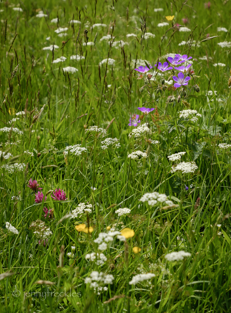
Muker's hay meadows bloom with wild flowers for just a few weeks in June, and I guess it depends exactly when you visit as to what flowers predominate. There were plenty of buttercups but less red clover and fewer of the purple geraniums (wood crane's bill?) than I remember from my last visit a few years ago.  


You can't really stray from the central path, which is there to prevent people trampling the plants, so proper identification of all the species present is not really possible. 


There are barns in every field. The long 'through stones', which bind the inner and outer skins of the walls together, characteristically project beyond the face of the wall, in rows. 


Further up the dale, farmers had already started cutting the hay. The drying piles have a wonderfully sweet, clean scent, so evocative. 

Thursday, 14 July 2022

Muker

Swaledale mini break 5

Up the dale from Reeth, there is a string of small villages and hamlets, each with their own character.  One of the more attractive is Muker (pronounce it 'Mooker' rather than 'Mewker', I think), which is famed for its flower-rich hay meadows, still farmed traditionally thanks to grants paid to farmers to continue their conservation. The village was at one time a centre of hand knitting. It also has one of the few churches in the dale. For centuries, the only parish church was in Grinton, beyond Reeth, meaning that people had to carry their dead in wicker coffins as far as 16 miles for burial. There is an ancient footpath known as the Corpse Way, with coffin stones at intervals where the pallbearers would rest. In 1580, a chapel of ease in Muker was substantially rebuilt and a graveyard consecrated so that people didn't have to travel to Grinton. The church was restored in 1891 and you can see its tower in my first photo. 


The Swale flows from the north into Muker before turning to the east.  There were a lot of boulders in the river bed but very little water, a sign of the dry spring we've had. 

Wednesday, 13 July 2022

Reeth

 
Swaledale mini break 4

Reeth is the main settlement in Swaledale, in a lovely setting on a plateau above the river, with soaring views of the surrounding hills and moors. At the junction of Swaledale and Arkengarthdale, it became an important centre when lead mining became established in the hills during 18th and 19th centuries. Nowadays it is a tourist hotspot, with holiday lets, a couple of tiny shops, several pubs, cafés and some small art galleries. It's all set around a green, which would be lovely if it weren't also the main car parking area in the village! 


In the evening there was a lively game of quoits going on, a traditional game, attended by a small but enthusiastic crowd of onlookers. Quoits involves throwing hoops - in this case heavy metal ones, with the aim of encircling a pin sticking out of a bed of clay. The tactics looked to involve flipping your opponent's quoit out of the way or blocking it by clever positioning of your own quoit. It was a lot of fun. 


Tuesday, 12 July 2022

Tan Hill Inn


Swaledale mini break 3

Wherever you go in Pennine Yorkshire you're liable to stumble across The Pennine Way, Britain's oldest and perhaps most iconic long-distance footpath, all 268 miles of it. To walk it takes 16-19 days. It begins in Edale in Derbyshire and weaves its way north through some of our bleakest yet loveliest scenery: Stoodley Pike, the Calder valley near Hebden Bridge, Brontë country around Haworth, Malham, Pen Y Ghent and Ribblesdale, Hawes in Wensleydale and then over to Swaledale by Great Shunner Fell. Almost half way and you arrive here (above). Looking at the broad track here, coming from the south, you could be forgiven for thinking it might be an easy walk but that is deceptive. Even in the more 'civilised' stretches the path isn't always clear or easy underfoot. You only have to look in the other direction, northwards, to see how empty these moorlands are, although the A66 cross-country road is hiding in the far distance. 


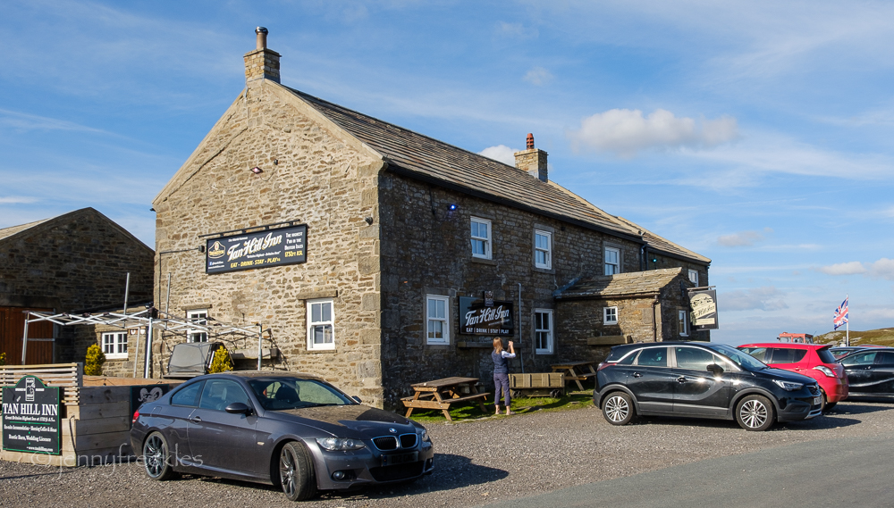
The bonus of this leg is that you can, if you choose, spend the night here, in Britain's highest pub: The Tan Hill Inn. I didn't stay the night but I did have dinner, a hearty pub meal of gammon, eggs and chips. It was my first visit to this place of legend and I wasn't disappointed. It's a cosy and welcoming hostelry. 


It may be the only pub in the country to have a snowplough and two snowmobiles parked in the car park! That's because it quite frequently gets snowed in in winter.  Indeed, last December, 61 guests enjoying an Oasis tribute band gig became stuck here for three days and nights, stranded by Storm Arwen. Read about it HERE. I think they actually had a great time and it got loads of publicity.  The landlady said: 'I think it was a happy story and that was why it snowballed as it did.' Very punny!


The pub dates back to the 17th century and in the 18th century it was surrounded by coal mine workings and miners' cottages, so it wasn't nearly as isolated as it is now. The last mine closed in 1929 but the pub stayed open, frequented by local farmers and then by the increasing number of tourists as the motor car became more popular. It must be quite a challenge to own and run the inn but even when I was there it was doing a brisk trade. Another tick off my bucket list, anyway. I've always wanted to see it. 

By the way, if you were following the Pennine Way, there is at least another eight days walking to the end point at Kirk Yetholm in the Cheviots. Some amazing adventurers actually run The Pennine Way, non-stop, in the ultramarathon Montane Spine Race, held twice every year in summer and in mid-winter. They carry GPS trackers so it's rather fun to watch the runners' progress on the tracker.  The course record has just been broken this year, with Tiaan Erwee, a runner from Guernsey, blasting through in a remarkable 70hrs 46 mins, with just 20 minutes sleep en route!


Monday, 11 July 2022

Swaledale's field barns

Swaledale mini break 2

The road between Thwaite and Keld winds its way along the valley side around Kisdon Hill. It's a good place from which to see the characteristic Swaledale barns. How many can you count in the photo above? It's a very distinctive agricultural landscape, shaped over at least the past 250 years, and its significance is thankfully now being recognised so that many of the barns are being restored and their history recorded. 


The field barns are locally called 'cow'usses' (cow houses) and are closely tied in with the landscape and seasons, so that hay would be (is still) cut and dried in the meadows, then stored in the barn to be used to feed cattle in the winter. The barns typically have sections, the mew being where the hay is stored and the shippon (byre) where cows were brought in to overwinter. The muck from the cows was then used to fertilise the meadows, in an ongoing cycle. I didn't see many cows in the valley; it now seems to be mostly sheep farming though there may also be some cattle. Certainly Swaledale's meadows are still traditionally farmed and they are world famous for their abundant wild flowers. There's some fascinating information on this website HERE.

Being Yorkshire, there are plenty of the characteristic drystone walls, snaking improbably around the field slopes.  

The River Swale around Keld has some good waterfalls. Kisdon Force is quite a steep drop, though I didn't hike down to it this time. The one pictured - Wain Wath Force - is a gentler cascade, though there was very little water in the river; it has been such dry weather for weeks. 

There are still bikes all over the place, originally, I think, to celebrate the Tour de France stage in 2014, and then left, simply because they are fun. The one pictured was decked with Royal Jubilee bunting. 


Sunday, 10 July 2022

Buttertubs

Swaledale mini break 1

I was lucky enough to be able to have another short break last month, this time to the northernmost sector of the Yorkshire Dales: Swaledale. The journey up through the Dales from Saltaire is spectacular - from Airedale, up through Wharfedale, Langstrothdale, over Fleet Moss, down through Sleddale to Hawes in Wensleydale and then - most breathtaking of all - from Hawes over to Thwaite in Swaledale, via the Buttertubs Pass. That road is on my photo above - and the Buttertubs are in the two pictures below. 

The Buttertubs are 20m deep limestone potholes, supposed to be where farmers would rest on their way to the market in Hawes. It's said that they would lower their tubs of butter into the holes to keep them cool. Not sure how true the old tale is, but they are certainly interesting natural structures. 

The road's other 'claim to fame' was that it featured as one of three categorised climbs in Stage One of the 2014 Tour de France - 'Col de Buttertubs'. It is a particularly challenging climb that cyclists still test themselves on. 

There are one or two places where you can safely pull off the narrow road to take in the amazing views. Swaledale is relatively sparsely populated compared to the other dales, but probably has more stone barns (cow 'usses) than all the rest put together.